


Reduce sediment production (watershed management)
74,000 Mm³ (original)
6,450 MW
2018 (expected)
The Grand Ethiopian Renaissance Dam is designed to trap 100 years of sediment inflow. Lack of sediment data and rapid land degradation may result in higher sediment yields than expected. Reduction of sediment inflow through watershed management is key to achieving long-term sustainability. Debre Yakob watershed demonstrates a successful example of economically self-supporting watershed management.

The Grand Ethiopian Renaissance Dam (GERD) is a 6,450 MW hydropower project nearing completion on the Blue Nile in Ethiopia, located about 30 km upstream of the border with Sudan. It will be the largest hydropower project in Africa. Owned and operated by the Ethiopian Electric Power company, the 145-m-tall roller-compacted concrete gravity dam will flood 1,874 km2 at a normal pool elevation of 640 m, and will have a tributary catchment of 172,250 km2. With a volume of 74 km3 (of which 14.8 km3 is dead storage), the reservoir can hold about 1.6 years’ worth of average flow of the Blue Nile - 48.5 km3/yr - at the El Diem gage station, just below the border in Sudan (Conway 1997).
The major impediment to sustaining the operation of GERD indefinitely is reservoir sedimentation. Due to its large hydrologic size, essentially all of the sediment that enters the GERD reservoir will be trapped unless turbid density currents can be released. Given the national importance of the GERD project as a sustainable source of power, together with the economic and social consequences of degraded land use in the watershed, land management to reduce erosion will result in long-term benefits at multiple levels.
For the recent sediment yield reported at El Diem, and estimating a specific weight on the order of 1.0 t/m3 for sediment deposits, the reservoir’s dead storage capacity is sufficient to trap ~100 years of inflowing sediment. This is an accepted conventional design criterion, but it does not result in long-term sustainability. At reservoirs with a large capacity:inflow ratio, such as GERD, the feasible methods of sediment management are typically limited to the release of turbid density currents and the reduction of sediment inflow through watershed management. This latter approach is the topic of this case study, which focuses on the Debre Yakob demonstration watershed (‘learning watershed’) in the Lake Tana sub-basin.
The basin of the upper Blue Nile tributary to the dam drains the Ethiopian highlands. The Blue Nile has a single wet season and flow is highly seasonal, as shown in figure 1. The Ethiopian highlands range from about 500 to 4,533 m in elevation, with average rainfall varying regionally from 600 to 2,200 mm/year.
Sediment concentration peaks one month prior to the discharge peak. Trend analysis at the El Diem gage showed a 61 per cent increase in sediment load, from 91 Mt/yr for the 1980-1992 period to 147 Mt/yr for the 1993-2009 period, and was associated with a significant increase in suspended sediment concentration, especially during the rising limb of the wet season (Gebremicael et al. 2013). The recent sediment yield is 835 t/km2/yr across the 176,000 km2 watershed tributary to the El Diem gage. A recent study by the Water and Land Resource Centre (WLRC) using a very detailed modelling approach indicates that sediment entering GERD will be in the order of 287 million M3/year (WLRC, 2017 unpublished), much higher than previous predictions.
About 83 per cent of Ethiopia's population lives in rural areas and many derive their livelihoods from agricultural and environmental resources, primarily rain-fed agriculture and cattle grazing. Over 90 per cent of the cropland consists of small scale rain-fed household production systems. Ethiopia’s dramatic population expansion over the last 50 years, and future predictions of a growing population (see figure 2), has placed extreme pressure on the land, resulting in accelerated erosion, soil degradation, and rural impoverishment. Land degradation occurred because the production system was based on continuously expanding land for cultivation, rather than increasing the production per unit area, as described in the Abbay basin (Zeleke and Hurni 2001):
As cultivated land was expanded at the expense of other land use and land cover units, grassland declined, resulting in less available fodder and a decrease in the number and quality of livestock. This led to a shortage of animals required for plowing and transport, as well as to a reduction of income and food from animals and their products. This series of related impacts indirectly affected the traditional land management system. When livestock and fodder was plentiful (in the 1950s), manuring was an important practice in the area. It increased soil fertility and hence production without extra cost to the farmer except for labor. After fodder availability and livestock had decreased, manuring (traditionally called hura) was gradually reduced. Moreover, manure is now in greater demand than ever not only because of the lower number of livestock but also because its use as a source of fuel has increased due to reduction of fuelwood.
Bare lands were used as grazing land. Livestock were forced to stay on these land units, especially during the cropping season, although there was little for them to feed on. This is one of the practices adopted by farmers when the population grows and land becomes scarce. The farming system remains traditional while most of the grasslands are converted to cultivated lands. In this case, both livestock and cultivation took over marginal lands, eventually leading to even more severe land degradation.
The Ethiopian highlands within the GERD watershed are considered to be one of the severest cases of watershed degradation in the world. Sediment yields in the Lake Tana sub-basin, where the Debre Yakob site is located, average about 2,500 t/km2/yr, and in the areas of highest erosion, hazard sediment yield may be as high as 6,500 t/km2/yr. Areas with the highest erosion potential have been analysed and identified using the SWAT model, together with climatic time series and GIS spatial databases of soil characteristics (Setegn 2008).
Thus, much more is at stake than the issue of reservoir sedimentation, because the degraded soil conditions result in rural poverty and food insecurity. It is essential to maintain this soil on the farms to support productive and sustainable agriculture, just as it is necessary to keep it out of the reservoir to sustain long-term hydropower production.
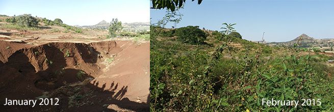
The Debre Yakob watershed encompasses about 325 ha, and is located at 11º 16’ 59" N latitude and 37º 13’ 45" E longitude. Rainfall averages about 2,300 mm/year. It was selected as a ‘learning watershed’ by WLRC in 2012 to serve as a demonstration site for a variety of interventions aimed at improving land management practices in a way that would substantially improve the economic circumstances for farmers, while simultaneously reducing soil erosion. Typical of the region, the Debre Yakob watershed was severely degraded by overgrazing, resulting in soil denudation and gullying. To transform the local watershed, the first order of business, and the greatest challenge, was to achieve a shift from free grazing across the entire landscape, to the use of enclosures and cut-and-carry feeding of the livestock (figure 3). Without relieving the continuous grazing pressure, it would not be possible to achieve re-vegetation needed to control erosion.
There was considerable initial scepticism in the Debre Yakob community, which had no prior experience with a cut-and-carry livestock management system. Many believed it would not work. However, by working closely with cooperating farmers in one area of the watershed, and by providing the initial funds to build check dams and plant vegetation to stabilise gullies, it was possible to demonstrate that the check dams would accumulate eroding soil and grow luxuriant vegetation (figure 4). By the end of the first wet season, the amount of forage production was exceeding the needs of the livestock that, previously, had barely survived when grazing freely. Feeding in one of the livestock enclosures is shown in figure 5.
The key to long-term success in watershed management lies not in the building of erosion control structures, but in changing the economic activities of the community to embrace sustainable production systems."
With grazing pressure removed, re-vegetation occurred rapidly in the moist soil held by the check dams. Vegetation also began to recover on the upland soils once the livestock was confined and young plants were not immediately consumed by wandering animals. Vegetative growth enhanced soil infiltration capacity and improved soil structure, leading to higher soil moisture levels and, in turn, more vegetation, establishing a positive feedback loop of land restoration.
By eliminating free grazing and producing sufficient forage to support the livestock, the community saw the benefits of changing their production systems. Attention then turned to enhancing the value of farm production through multiple avenues. The most important management strategies employed at Debre Yakob are:
At Debre Yakob, the economic benefits to farmers provided by the technology package are clearly evident, not only in terms of increased production, but also in purchasing power. Among the earliest signs of improved living standard is the replacement of thatched roof with corrugated iron sheets. As development proceeds, financing structures to facilitate productive investment become more important, for example, to allow the purchase of a communal truck to transport products to market instead of selling to a middleman at depressed prices.
While many of these activities do not directly influence soil management, they are all part of a farming technology package that makes responsible land management self-sustaining. The key to long-term success in watershed management lies not in the building of erosion control structures, but in changing the economic activities of the community to embrace sustainable production systems. To be productive and sustainable these systems must retain topsoil on the farm. As a result, erosion control occurs as a natural and self-sustaining product of a successful farming system, as opposed to a top-down programme aimed at benefiting a downstream hydropower reservoir and sustained by costly subsidies. The importance of focusing on the household economic unit is underscored by the differences between unsuccessful and successful long-term interventions in Ethiopia (Zeleke 2015):
In the past focus was given only to rehabilitation of watersheds and less was done on activities that enhance income at household level. This was proved wrong over time as rehabilitation intervention alone didn’t enhance income within a short time and as a result many watershed development interventions fell back to previous situations. Over the years we have learned that any watershed development intervention should have economic development interventions as a major component of the watershed development plan and this was best organised in the form of homestead development intervention. We have seen that many households graduated from food insecurity through the combination of rehabilitation and economic development interventions.
The key underlying strategy is to greatly enhance productivity and economic value through optimal management of the best soils, while converting the poorer and steeper soils to woodlands (eg firewood, building materials), pasture, or tree crops. Multiple avenues need to be pursued to enable the farmer to enjoy higher income and enhanced economic security, providing self-sustaining economic incentives derived from the land itself which guides farmers to maintain and improve soils and sustain vegetative cover without additional external incentives.
Reducing sediment yield by changing land use requires a significant and sustained effort, potentially requiring the intervention with tens of thousands of small farmers. Realistically, an intervention on this scale can only be achieved through the participation of multiple entities including government, NGOs, and the private sector. In some cases, with small watersheds and known erosion hot-spots, there may be the opportunity for effective unilateral action by the dam owner. However, more typically a watershed management project is not a go-it-alone project for the dam owner, but may involve many organizations at multiple levels, from the local community up to the national government level. For example, to address land management issues in the North Fork of the Feather River (California, USA), hydropower owner PG&E joined in a formal memorandum of understanding with 17 other organisations (Morris and Fan 1998).
Hydropower producers can play key roles in this process by using their available funds to help develop and demonstrate viable technology packages, and to sustain work at demonstration sites which can then be copied and disseminated throughout the watershed by others through both formal workshops and informal means. An economically successful system is likely to be adopted by others, on their own, given access to the information and provided learning opportunities. This is already happening at Debre Yakob Learning Watershed.
In selecting project areas for intervention, it is essential to understand the natural background rates of erosion and sediment yield, and to select for intervention those areas where the erosion rate has been greatly accelerated by poor land use practices, and where interventions can be applied successfully and sustainably. Tools such as the SWAT model coupled to GIS databases can be extremely helpful in preparing a sediment budget and identifying areas of greatly accelerated erosion. Equally important is the development of locally-relevant technology packages that are economically self-sustaining.
Watershed management programmes are not always successful. Key factors that point to long-term success at Debre Yakob include the development of technology packages that are economically self-supporting because they increase on-farm income, and a climate with sufficient moisture to achieve rapid re-vegetation. Establishment of such learning watersheds in different parts of hydropower catchments help to educate and change the attitude of local communities, experts and policy-makers. This facilitates expansion of successful technology packages into other areas.


Conway, D. 1997. “A Water Balance Model of the Upper Blue Nile in Ethiopia.” Hydrological Sciences Journal 42 (2): 265–86. doi:10.1080/02626669709492024.
Ethiopia Ministry of Agriculture. 2016. “Guidelines for Development Agents on Soil and Water Conservation in Ethiopia.” Addis Ababa: Ethiopia Ministry of Agriculture.
Gebremicael, T.G., Y.A. Mohamed, G.D. Betrie, P. van der Zaag, and E. Teferi. 2013. “Trend Analysis of Runoff and Sediment Fluxes in the Upper Blue Nile Basin: A Combined Analysis of Statistical Tests, Physically-Based Models and Landuse Maps.” Journal of Hydrology 482 (March): 57–68. doi:10.1016/j.jhydrol.2012.12.023.
Morris, G.L., and J. Fan. 1998. Reservoir Sedimentation Handbook. New York: McGraw-Hill Book Co.
Setegn, Shimelis Gebriye. 2008. “Hydrological and Sediment Yield Modelling in Lake Tana Basin, Blue Nile Ethiopia.” Stockholm: Royal Institute of Technology.
Zeleke, Gete. 2015. “Exit Strategy and Performance Assessment for Watershed Management: A Guideline for Sustainability.” Addis Ababa: Water and Land Resource Center of Addis Ababa Univ.
Zeleke, Gete, and Hans Hurni. 2001. “Implications of Land Use and Land Cover Dynamics for Mountain Resource Degradation in the Northwestern Ethiopian Highlands.” Mountain Research and Development 21 (2): 184–91. doi:10.1659/0276-4741(2001)021[0184:IOLUAL]2.0.CO;2.
