Flushing
Upstream sediment trapping
Catchment management
Adaptive strategies (protective coating)
8.50 Mm3
510 MW
2008

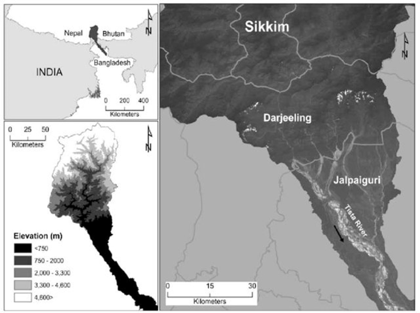
The Teesta V Power Station is one of 24 power stations owned and operated by the National Hydroelectric Power Corporation (NHPC Ltd.). It is located in the state of Sikkim, India, on the Teesta River, which originates from the Cho Lamo glacier above 7,068 metres and flows southward through steep slopes and extremely rugged terrain into the foothills of the Sikkim Himalaya and West Bengal (Figure 1).
This run-of-river project has a 88.6 meter high, 176.5 m long, concrete gravity dam impounding a regulating reservoir for daily power peaking. The headworks divert flow into desanders and a 17 km headrace tunnel until it remerges at the powerhouse and flows back into the Teesta River through three tailrace tunnels (Figure 2). The powerhouse contains three 170 MW Francis turbines rated at a net head of 197 m and generates an average of 2,573 GWh per year. During the winter dry season, the project operates as a peaking plant. In the summer wet season (monsoon) it operates continuously at full power. The regulating reservoir provides about three hours of power peaking capacity. The main measures used to combat the high sediment load from the rugged landslide-prone terrain include seasonal sluicing (reduced water level) during the monsoon, multiple flushing events during the monsoon, use of desanders, and application of abrasion resistant coatings to abrasion-prone components. Land treatment has also been applied in limited areas of the catchment.
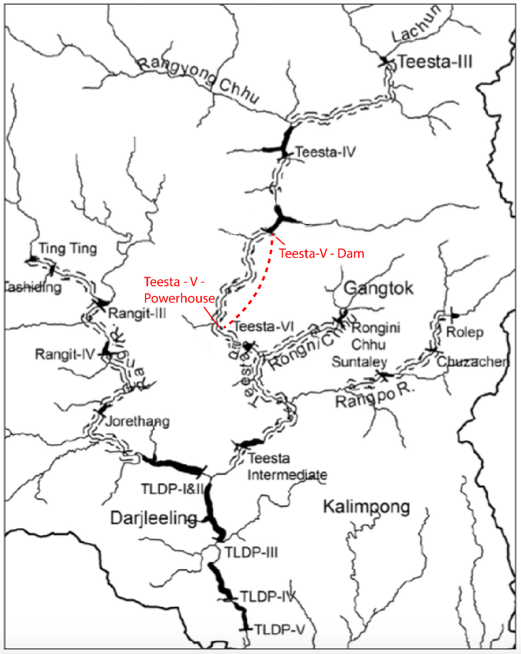
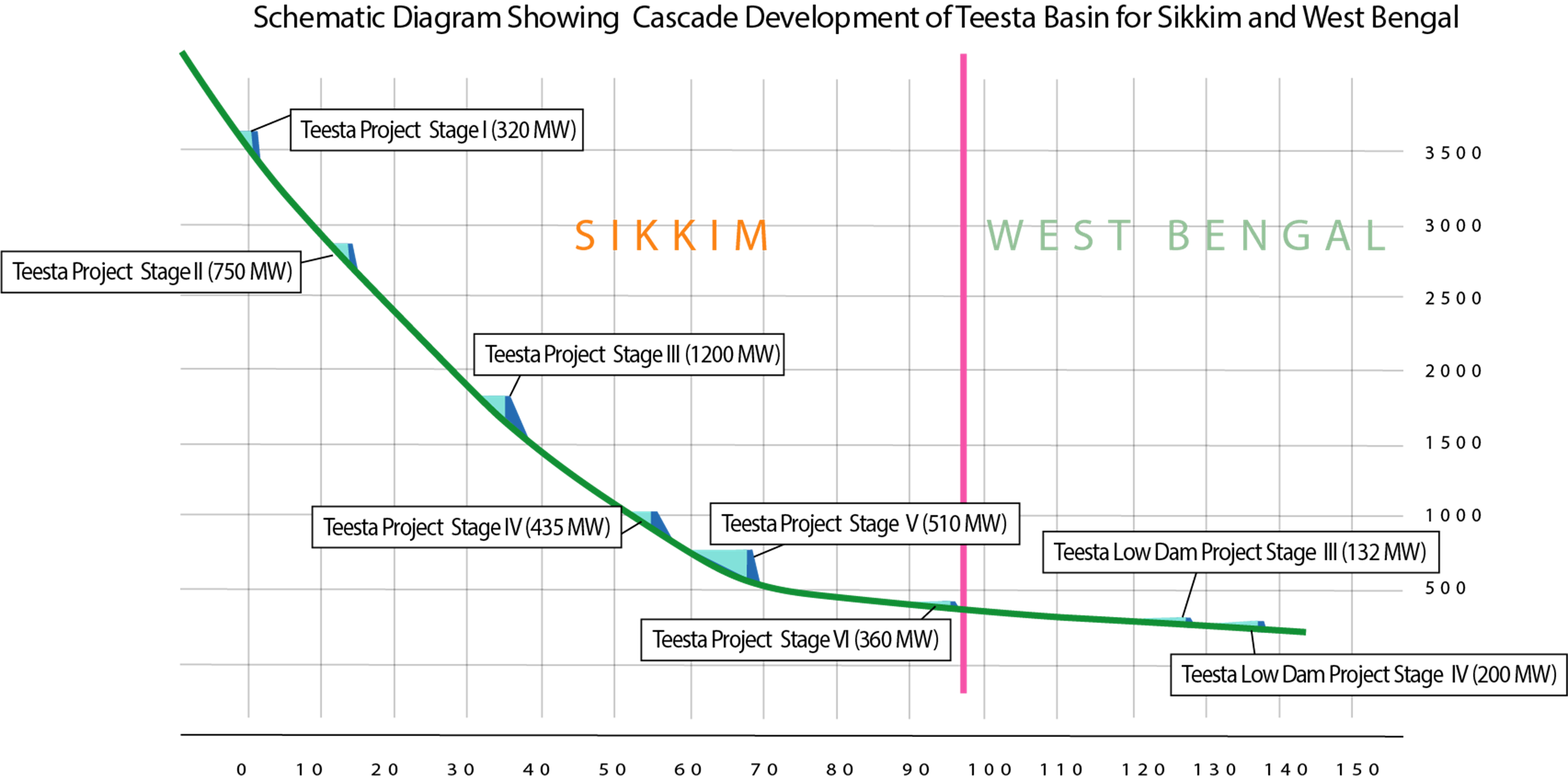
The Teesta watershed encompasses most of the area of the State of Sikkim and has multiple hydropower projects along its length (Figure 3).
It drains a catchment area of 4,307 km2 and constitutes one of the major tributaries of the Brahmaputra-Jamuna River, whose waters eventually drain into the Bay of Bengal. More than 59 percent of the Teesta River catchment area lies above 3,000 m and is characterised by steep (>27°) to very steep (>65°) slopes. The average discharge in the river varies from a maximum of 645 m3/s during the monsoon, to a minimum of 61 m3/s in January. High rainfall over the steeper slopes (~2,300 mm/year) produces high rates of run-off and soil erosion, with extreme loads contributed by slope failures. The project experiences high variability in the annual peak flow and sediment load. From 1984 to 2005, the peak annual flows ranged from 690 m3/s (in 1994) to 2,593 m3/s (in 2002). Flow variability is summarized in Figures 4 & 5.


Annually the mean sediment load is around 31.4 million tonnes, corresponding to the mean annual runoff of 25.2 billion m3. The sediments in the river are characterized by the dominance of sand particles mixed with gravel . The mean grain size ranges from 0.95 to 3.62 mm. The sands are occasionally laden with the coarser particles mostly with cobbles and gravel. Inflows to the Teesta-V reservoir are also influenced by the operations of the upstream Teesta-III and Dikchu projects which were commissioned in 2017 and 2016 respectively. Due to limited storage at Teesta-V, the operational flexibility is also limited by the base flow required to continuously operate the plant. Nevertheless, the current operating procedures are very efficient with respect to maximizing power and minimizing spillage.
The Teesta – V Power Station faces significant challenges regarding assessment and management of erosion and sedimentation issues largely owing to its location in the seismically-active Himalayas and the naturally high rates of weathering, erosion and landslides, all of which contribute to the high sediment loads. At commissioning in 2008 the Gross Storage at Full Reservoir Level (FRL) was 13.25 Mm3. However, by post-monsoon 2017, after nine years of operation, the gross storage had been reduced to 8.7 Mm3, a 30 percent reduction, and of this 5.3 Mm3 was active storage.
Erosion and abrasion of the turbines due to sediments also have posed a significant issue, and has been a priority management objective since the project’s feasibility studies. Furthermore, the main environmental impacts, i.e. mitigating the risk of landslides and minimizing environmental sediment input, are also related to sediment as well. Localized socio-economic activities in the form of sand and gravel extraction from the river above the Teesta-V site was not observed to significantly impact the amount of sediment deposit in the reservoir.
Erosion and sedimentation risks to the project were well assessed during the project development stage and a number of management measures were built into the project design and operations. The project was designed with three desilting chambers (each of 20 m wide, 22.5 m deep, and 315 m long). In addition, a catchment management plan, regular sediment flushing as well as extensive monitoring of the catchment and the applied sediment management measures were planned for early on in project design.
Catchment treatments were applied to reduce soil erosion and minimize the sediment load on the reservoir. A total of 10,710 hectares of land in the Teesta-V catchment, representing <3 percent of the catchment area, were treated over a period of 10 years following a planned schedule. The land treatment focused was predominantly on forest land, but also addressed some agricultural land, using both biological and engineering treatments.
During the dry season the reservoir is held at a high level, except for power peaking operations. During the wet season the reservoir level is lowered to perform a seasonal sluicing operation, generating higher flow velocities that reduce the rate of sediment trapping in the reservoir. Additionally, multiple empty flushing operations are also conducted during the monsoon to remove sediment deposits. These flushing events are coordinated with the upstream Teesta-III project. Reservoir water levels during a typical year are presented in Figure 6 showing four flushing events.

To initiate flushing, the reservoir level is lowered to its minimum level by slowly opening the spillway gates until they are fully open, while the intake and tailrace tunnel gates remain closed. Free flow is then maintained through the reservoir for at least 12 hours, until the sediment concentration entering the reservoir equals to the sediment concentration downstream of the dam. Multiple flushing events help even-out the sediment discharge to the river downstream of the dam. Reservoir flushing also minimizes the accumulation of organic debris that could decompose to release methane.
When inflows equal or exceed 350 m3/s, the intake gates are opened for flushing the desilting chambers. Because almost all sediment is delivered during the monsoon, flushing is rarely required during periods of low flow. The “Reservoir Operation and Silt Flushing Guidelines” manual establishes the time periods, inflows, and flushing procedures for the desilting chambers.
Continued research and development efforts and practical simulations by NHPC have been focused on reducing the damage to hydropower equipment caused by sediment erosion and abrasion. One approach successfully applied at Teesta-V involves application of an abrasion-resistant surface coating on parts subject to abrasion. The High Velocity Oxygen Fuel (HVOF) thermal spray coating extends equipment life by significantly increasing resistance to abrasion and corrosion. The coating is applied to the runner, guide vanes, cheek plates, etc. and has demonstrably improved the longevity of these components.
The dam's civil structures are also heavily impacted by sediment, The spillway is regularly damaged by boulders and other bed load and is repaired each year after the monsoon.
The average monthly power generation is shown in Figure 7. Despite the challenge of high sediment loads, the plant has sustained a high Plant Availability Factor (PAF). The nominal availability factor of 85 percent was achieved in eight out of the first 10 years, and 2017-2018 saw the highest plant availability factor at 97 percent. This is exceptionally high, considering that the average PAF of hydropower plants in India is 92 percent. The target is currently based on assumed 20 days of maintenance per unit, and 4 x 36 hours of reservoir flushing.

The close monitoring of erosion and sedimentation ensures that emerging risks and opportunities can be identified and responded to. The risks associated with landslides, including increased sediment load on the reservoir and risks to infrastructure integrity and public safety, are monitored through a variety of processes. Landslides were specifically mapped during the project feasibility studies, and both old and new landslides are monitored. In particular, the reservoir rim and the local area is routinely surveyed for any destabilization or landslip activity. This is supplemented by frequent visual inspections of the long-term stability of rehabilitated areas of land disturbed by construction activities, including muck, spoil and waste dumps.
Sediment inflow into the reservoir is monitored in a variety of ways at the Teesta–V project. Suspended sediment samples are taken daily at the gauging station upstream of the reservoir as well as at one of the turbine draft tubes in the power station, and supplemental measurements are taken intermittently at the intake or the spillway. During the monsoon season, when high sediment loads are mobilized, samples are taken downstream of the dam when the gates are open. Data is analyzed at an onsite lab and used to guide the timing and duration of reservoir sediment flushing and operation of the desilting chambers. NHPC maintains close communication between the dam and powerhouse regarding the sediment monitoring results and the sediment management activities. Reservoir survey cross-sectional (bathymetry) monitoring is also performed by echo sounder, before and after each monsoon season, using an interval of 100 m between cross-sections. These data are used to monitor the amount of sediment in the reservoir and the effectiveness of sediment flushing. Because multiple reservoirs occur along the river, flushing activities are coordinated across multiple projects.
The post-construction Environmental Impact Assessment (EIA) presently being implemented for Teesta-V, includes the evaluation of satellite imagery to analyze pre-project, during-construction, and post-construction changes in land use and land cover patterns as well as the erosion intensity of the catchment and project area. This study will evaluate the effectiveness of all management plans implemented for Teesta-V and make recommendations that will influence further management activities.
This case study illustrates a multi-faceted approach to sediment management in a Himalayan environment with a high sediment load. The approach involves watershed treatment in key areas to reduce the inflowing load, empty flushing high flow periods to remove sediment by scour while simultaneously sluicing foodborne sediment through the reservoir, as well as measures to adapt to the high-sediment environment such as the application of turbine coatings to reduce abrasion. This multi-pronged approach is characteristic of the variety of measures required to achieve effective results at sediment-challenged sites.
Hydropower Sustainability Assessment Protocol. 2019. Teesta-V Power Station, Official Assessment. https://www.hydrosustainability.org/published-assessments/teesta-v
Saha, Sudip & Roy, Mrinal & Reza, A.H.M.Selim. (2017). Textural Characteristics of The Sediments of The Tista River, Rangpur, Bangladesh. 12. 73-79.
Shi, H., Ji, Z., Lu, Q. and Wang, D., 2019, May. Study on Fluvial Processes and Sediment Transport Capacity of Teesta River in Bangladesh. In World Environmental and Water Resources Congress 2019: Hydraulics, Waterways, and Water Distribution Systems Analysis (pp. 399-410). Reston, VA: American Society of Civil Engineers. https://ascelibrary.org/doi/pdf/10.1061/9780784482353.038