Dredging and monitoring
Banjë - 400M m3, Moglicë – 380 M m3
269 MW
Banjë - 2016, Moglicë – 2020

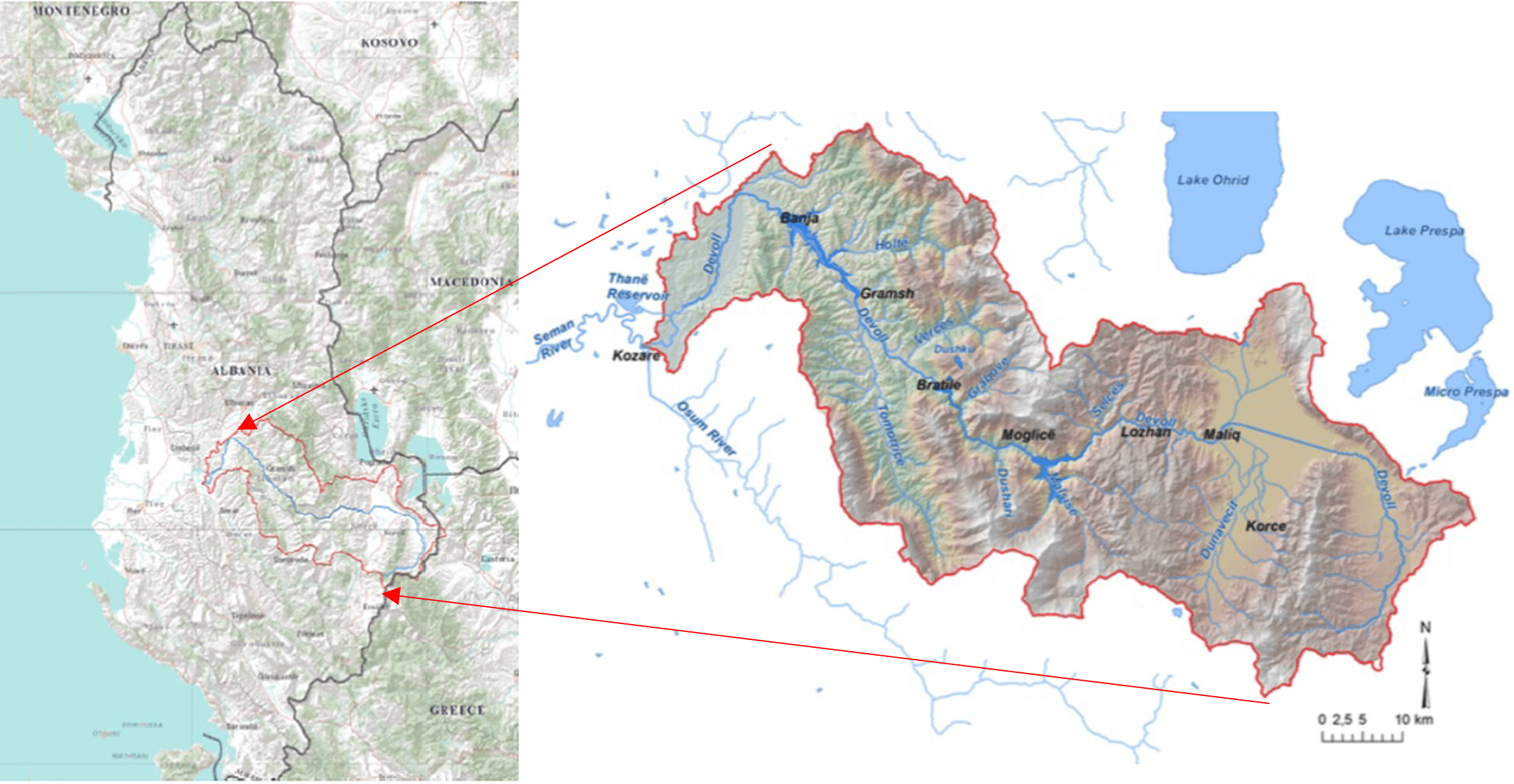
The Devoll Hydropower Project (DHP) consists of two power plants; Banjë (72 MW) and Moglicë (197 MW), both located on the Devoll River in southeast Albania. [2] Devoll river is the main tributary which joins the Osum River to create the Seman River which discharges to the Mediterranean Sea. Above this confluence, the Devoll has a catchment area of approximately 3119 km2 and elevation ranging from 22 m to 2386 m. [4]
Banjë dam is located 70 km southeast of Albania’s capital Tirana, and Moglicë a further 50 km upstream (see Figure 1). The 80m high Banjë dam incorporated the former unfinished Banjë project structures. Moglicë is one of the world’s tallest asphalt core dams, at 167 m. The annual hydropower generation from both plants of 700 GWh increased Albania’s electricity generation by approximately 13 percent when they came into operation. [2]

DHP contributed to the research, development and testing of technologies in sedimentation monitoring and management such as through the implementation of a tailored dredging system.
The Devoll River is a tributary to the Seman River, which has been referred to as the most turbid river entering the Mediterranean Sea, estimated to deliver 16.5 million m3 of sediment annually to its delta. Sediment yield within the Devoll catchment above the dams is estimated at 4.9 million tonnes per year at Banjë and 2.4 million tonnes per year at Moglicë. [1]
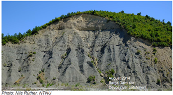
High sediment yield results from massive gullying and landslides within the catchment due to a history of deforestation on weak sedimentary parent rocks. The two main types of rock are the sedimentary flysh, i.e. shales and sandstone, and the harder magmatic ophiolite. Landslides are a common occurrence in the catchment due to the presence of steep, unstable slopes of extremely weak and highly weathered rock, with erosion accelerated by vegetation clearance and intense rainfall ranging between 600 mm to 1900 mm. An example of the scale of erosion is illustrated by Figure 2.
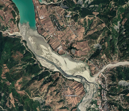
Large volumes of sediment deposition in the river have created a braided morphology along the Devoll and its main tributaries, with large deposits of sand, gravel, fine silt and clay, as seen in Figure 3. Braided conditions occur when the sediment load exceeds the river’s transport capacity, causing the river channel to move back and forth as the river valley accumulated more and more sediment. There were no prior historical data of Devoll river sediment and water quality. Following the development of the DHP, ongoing monitoring has been implemented within the catchment to better understand sediment patterns.
High sediment deposition in the reservoir poses a challenge of reduced reservoir lifetime and abrasion of the power generation turbines. From previous studies, Banjë reservoir is expected to lose about 3.5 million m3 (approximately 1percent) of its volume per year due to sediment deposition, and 0.5 percent per year at Moglicë reservoir. [1] Additionally, the high risk of landslides and slope instability are of significant concern for accelerating sediment accumulation in the reservoirs and for the project’s safety. For example, slope instability on the left bank of the Moglicë dam site delayed construction. The area around the Moglicë reservoir has a steeper topography and more potentially unstable areas than at Banjë reservoir. An area near the Moglicë was recognised as a national monument for study purposes following a large landslide of approximately 1 million cubic meters in 1974. In some areas, entire mountain sides have been eroded away and the remaining slopes are steep, unstable and will most likely continue to produce eroded soil material regardless of any revegetation attempts. [4]
DHP has taken steps to control erosion at localized areas of concern through its Environmental Management and Action Plan. This included the identification and avoidance of sensitive areas and implementation of an afforestation program for Banjë and Moglicë. To address erosion of the Banjë reservoir shoreline, a 3 m wide strip (18.5 ha) was afforested around 70percent of the reservoir perimeter, with additional catchment afforestation programme covered 255 ha. This afforestation programme was a legal requirement to compensate for the removal of forested areas within the reservoirs, but was also designed to maximize erosion control benefits. However, these measures will be of negligible impact in reducing the inflowing sediment load derived from massive areas of steep, unstable, and actively erodiong slopes in the tributary watershed.
At the time of dam construction, DHP installed a hydrosuction dredging system at both the Banjë dam and Moglicë dam to transfer sediment by gravity downstream of the dam (Figure 4). This measure will help maintain reservoir storage volume and increase operational efficiency by reducing turbine abrasion and sedimentation around the intake. The dredging system is composed of a 1200 mm diameter casing pipe and a HDPE outlet pipe inside the casing pipe, which are accessible for inspection [3]. The dredge at Banjë has the capacity to transfer 400 cubic meters of sediment per hour, which could control the estimated inflowing sediment load if the dredge could theoretically operate continuously (non-stop). The casing pipe was sized to allow installation of a larger dredge in the future. DHP continues to explore additional sediment management measures to ensure that the reservoir can sustain long-term operation despite the sediment load.

There were no systematic historical data for Devoll river sediment load and water quality prior to the development of the DHP. DHP, in collaboration with Statkraft’s central research, developed a sediment monitoring program to study sediment flows and optimize reservoir operations. This includes continuous sediment monitoring using ADCP (Acoustic Doppler Current Profiler), ongoing research to monitor and map out sediment deposition patterns, and evaluation of hydro suction dredging measures. Reservoir depositions will be monitored by bathymetric surveys of the reservoirs carried out every 5 to 10 years.
Additionally, due to the weak geology of the Devoll catchment, the areas that are at risk of landslides and the reservoir shorelines are monitored to check for stability with images taken at least quarterly. In 2015, Statkraft commissioned an historical InSAR (Synthetic Aperture Radar interferometry) analysis using satellite imagery from 2007 to 2010, to produce surface deformation maps to identify areas of mass movement around the perimeter of the reservoirs.
The DHP demonstrates ongoing sediment and catchment monitoring, and innovative technologies such as the hydro-suction dredging system to transfer sediment downstream of the dam. Through ongoing monitoring and research, the project will implement additional measures to ensure the project sustainability by gradually improving the sediment balance across the reservoir. [4]
1. Hydropower Sustainability Assessment Protocol. 2019. Devoll Hydropower Project. Official Assessment. https://www.hydrosustainability.org/published-assessments/devoll
2. Statkraft website. https://www.statkraft.com/en-al/projects2/banje-hpp/
3. Sedicon. https://sedicon.no/index.php/project/banja-hpp/
4. Adhikari, S., 2017. Evaluating Sediment handling strategies for Banja Reservoir using the RESCON2 model-A comprehensive study of the rapid assessment tool for sustainable sediment management (Master's thesis, NTNU). http://hdl.handle.net/11250/2465380
5. Ardiclioglu, Mehmet & Kocileri, Gerti & Kuriqi, Alban. (2011). Assessment of Sediment Transport in the Devolli River. 10.13140/2.1.2549.4085. DOI:10.13140/2.1.2549.4085