Dredging
Sediment bypass
4.9 Mm³
129.6 MW
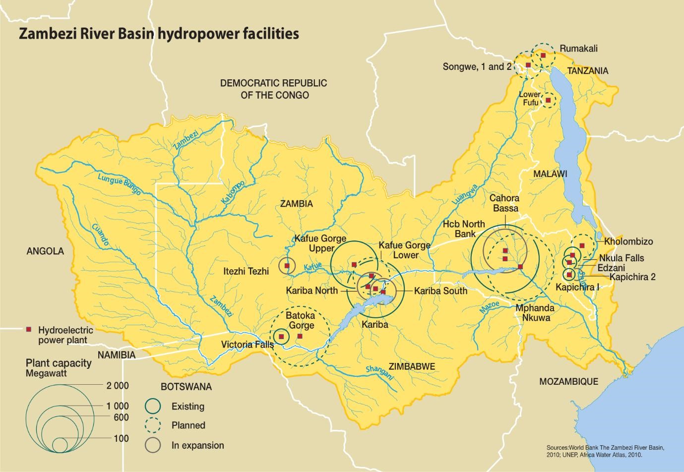
2000

Kapichira is one of the three hydropower plants on the Shire River Basin in the southern region of Malawi. The three hydropower plants (Nkula, Tedzani and Kapichira) have a combined capacity of 346 MW, together accounting for 88 percent of Malawi’s energy production. Kapichira contributes 33 percent of the national capacity. Kapichira is the furthest downstream and most recent addition to the cascade. Due to its design and operation as a run-of-river scheme, Kapichira has a small reservoir for the purposes of increasing the gross head and retaining coarse sediment transported by the Shire River. Although the reservoir is small, it is important to provide daily peaking services that are necessary to minimise the country’s recurring load shedding during peak hours. The Kapichira dam was commissioned in 2000 with two turbines, with a total installed capacity of 64.8 MW. In 2013, the station’s installed capacity was increased making a total of four turbines with a total generation capacity of 129.6 MW.

The Shire River is a tributary of Zambezi River. It flows from the outlet of lake Malawi approximately 410 km south and southeast where it meets the Zambezi River at Ziu Ziu in Mozambique. The Shire River is categorised into three sections: The Upper Shire, Middle Shire and Lower Shire sections. The Upper Shire catchment has a flat gradient (0.12 m per Km) characterised by seasonal tributaries that are very prone to flash flooding. Kapichira’s immediate catchment is in the Middle Shire section with a relatively high gradient of 3.6 m per km and high hydropotential owing to a total fall of 370 m through a series of rapids and cascades. The Lower Shire starts at Kapichira and flows south to the border of Mozambique where the Shire joins the Zambezi River. This lower section of the river also has a very low gradient of 0.22 m per km.
The Shire Basin is characterized by torrential rainfall of high intensities and is occasionally traversed by residual tropical cyclones. The basin is prone to extreme flooding events, such as the severe flash flooding of 2001/2. Peak rainfall takes place between December and March and at times exceeds 1,000 mm/ annum in the high escarpment. Mean annual rainfall in the Shire River basin is 903.7 mm.
The estimated mean annual runoff for the Shire River Basin is 1,853 m3/s, with a coefficient variation of 0.40. Runoff rises sharply between December and January, peaking on average in February – March, and falls steadily from April to November. During peak flooding, mean monthly runoff is approximately 800 m3/s and maximum annual flows range between 1000 and 1800 m3/s. In the dry season, minimum discharge can fall to between 64 - 765 m3/s in October and November. The Basin experienced significant changes in weather patterns over the last two decades. Droughts were experienced between 1991 and 1995, and extreme flooding events, such as the severe flash flooding of 2001/2 and 2015. The floods of January 2015 were the worst in recorded history and continued to further contribute to the degradation of the lower basin.
Degradation in the upper catchment due to deforestation increased issues with siltation and water quality deterioration in the river. This resulted in increased erosion of the flood plain in the lower portion of the Basin, and hence increased flooding and water quality deterioration in both Malawi and Mozambique. An assessment showed that the sediment yield had gradually increased from 0 – 1500 tons/ha/annum in 1984 to 0 – 4500 tons /ha/annum in 1994 and 0-5000 tons/ha/annum in 2014 with soil erodibility ratio of 0 – 20 tons /ha/annum, with few areas having 21 - 30 tons/ha/annum. The bed deposits in the Shire River consist of both sand and fine sediment .
The reservoirs of all three hydropower plants in the Shire basin have significantly lost their live storage capacity due to heavy sediment inflow from the tributaries feeding into the Shire River. A bathymetric survey of Kapichira reservoir in 2013 indicated that the reservoir had lost over 40 percent of its initial live storage and over half (59 percent) of its gross capacity after 13 years in operation. This is equivalent to a capacity loss at a rate of 4.3percent per year. The loss of active storage has subsequently reduced the duration of the much-needed peaking to meet the country’s energy needs. At Nkula dam, situated upstream of Kapichira dam, sediment loads were reported to contribute to a 10-12 percent reduction in power generation.
Sedimentation is more pronounced in the lower Shire River beginning at Kapichira due to the low river gradient which thus results in a low flow velocity, thereby increasing sediment settlement within the river. The high loads of sediment continue to raise riverbeds; filling up reservoirs and flood plains; affecting irrigation canals, fisheries, water supply and hydropower generation.

The high sediment load in the Shire basin is attributed to an increase in soil erosion that resulted from catchment degradation and land use change observed over the past forty years. All of the Shire basin is rated severely degraded, except for the national protected areas; wildlife and forest reserves (Figure 5). Continuous deforestation for charcoal production and poor cultivation practices such as on steep slopes are the major activities associated with land degradation within the catchment. Although programmes of land management are promoted, these have not been adequate in reducing the effects of sedimentation on water resources, aquatic life, transport and hydropower generation.
The full water level drawdown flushing applied was only able to preserve a small portion of the reservoir, which acted as a sediment retention basin, preventing the entry of coarse sediment into the power waterway as initially envisaged. The sediment deposition patterns in some parts of the reservoir, and as observed from bathymetry surveys, indicated that flushing operations were not effective at reducing rapid sediment accumulation. Flushing is better suited for narrow and deep reservoirs. The Kapichira reservoir on the contrary is wide and shallow. Thus, flushing wasn’t able to preserve the largest part of the reservoir active storage.

Sedimentation issues were identified at the design stage of the project, and it was recommended through the operational manual to flush sediment monthly. Between 2000 to 2011, flushing was done twice a month. The frequency of flushing decreased to only one to three times per year after 2011 as flows decreased in the river. Flushing operations were preferably carried out during the dry season to minimise losses in energy supply.
The annual flushing operations performed by complete drawdown had little impact on mitigating capacity loss to sedimentation in Kapichira reservoir. It was observed from the spatial sedimentation pattern in Kapichira reservoir that its geometry did not favour the implementation of flushing to preserve the storage capacity. Flushing operations would require one to three days of down time to empty and refill the reservoir, which was very costly for energy production considering that Kapichira contributes to 33 percent of national electricity capacity.
Since 2011, the flows in the Shire River continued to decrease due to low rainfall and this made it difficult to recover the necessary water levels in the reservoir after flushing. This created a major setback to continuing flushing operations as flows continued to decrease due to the recurring drought in the region. It was predicted that flows would continue to be low for the next few years until the water level in Lake Malawi (from which the river originates) reached the required level. Nevertheless, carrying out flushing operations during the dry season created adverse environmental impacts on the river system downstream of the dam.
The limitations of flushing to counter sedimentation impacts at the reservoir prompted a revisit to modify the applied sediment management strategies for the project in order to recover the lost capacity and sustain hydropower generation.
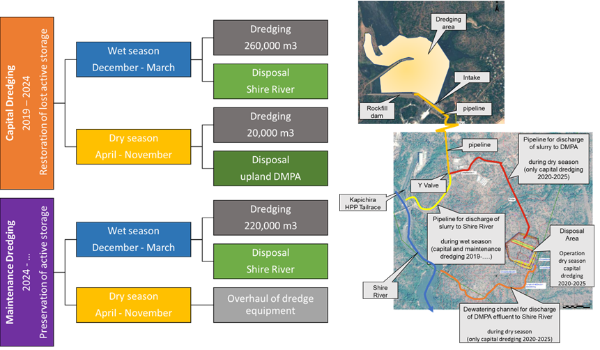
A new sediment management plan tailored for Kapichira was subsequently implemented from 2019. This included the use of a cutterhead suction dredge which was proven to provide an optimum environmental and economic solution specific for Kapichira reservoir. The replacement of flushing with dredging would ensure hydropower generation without the need to halt power generation to facilitate reservoir flushing by emptying and refilling of the reservoir. In addition, dredging would also support the operation of the irrigation intake on the right bank, which would otherwise be blocked by sedimentation.
The new management plan to dredge the reservoir is being carried out in two phases; first to restore the lost storage capacity, and thereafter to maintain the restored capacity and prevent further sediment accumulation.
1. Capital dredging to restore the active volume to its original capacity of 740,000 m³ from 200,000 m³ (2019-2024).
This dredging process was planned to remove 280,000 m3 of sediment deposits per year. This will restore the live storage to 740,000 m³ and increase the peaking time by an additional two to three hours. Restoration of the live storage will thereby result in an additional 11,500 MWh of additional peaking electricity generated per year.
A comprehensive analysis was also done to evaluate the disposal management options for the dredged slurry. In this first phase, the optimum environmental alternative is to release back part of the dredged sediment into the river and dispose the rest into an upland disposal facility. The disposal facility will be operated during low flows while the sediment release into the river will be done during the high flow seasons.
2. Maintenance dredging to preserve the active storage (2024 onwards).
Maintenance dredging was approved to maintain sediment continuity in the river by acting as a sediment bypass. This will be carried out in such a way that a proportion of the dredged sediment load that can be routed through the reservoir will be pumped downstream of the dam back into the Shire River. Unlike in the first five years where dredging is to be done throughout the year, maintenance dredging will only be done during the wet season (December- March). It was estimated that 220,000 m3 of sediment deposits will be removed per year through maintenance dredging.
The specific case study of Kapichira reservoir shows that dredging can replace flushing effectively for small reservoirs by preserving a larger portion of the active storage. This can especially be applied for relatively wide and shallow reservoirs, where flushing has a limited deposit removal efficiency.
This study also demonstrates the importance of critically revising and adapting sediment management plans to address new operational needs and changing sediment and reservoir conditions that could have emerged over the years. This will become more important in the forthcoming years due to the alteration of the hydrological conditions as a result of climate change. Sediment management will therefore provide one of the most robust adaptation strategies of water infrastructure to climate change. The review of sediment management plans is also necessary to adapt to new knowledge of sedimentation and management measures as more effective technologies emerge.
In February 2022, a severe tropical storm hit Kapichira reservoir and as a result the auxiliary spillway (fuse plug type) was activated. Another impact of this incident was that the reservoir was fully sedimentated. Dredging provides the necessary flexibility to remove deposits in reservoir areas where flushing could not be effective. Therefore, it can be stated that the implementation of dredging in Kapichira provides the flexibility to cope better with extreme events building thus resilience to the system.